Maps / Juan de Fuca Marine Trail
Juan de Fuca Marine Trail maps

I made seven maps covering the Juan de Fuca Marine Trail from China Beach to Botanical Beach, with the kilometre posts, campsites, trailheads and tide limits marked along the way. Each map is at 1:25,000 and can be printed on US Letter paper or used as a GeoPDF in TopoKit, where you can see your GPS location without cell service. The complete 11-page booklet is free to download, print and share.
Download the PDF8.9 MBThe PDF includes a cover, an overview of the trail, seven detailed maps and two pages explaining the map data, limitations and sources.
Using the maps in TopoKit
You can import the entire PDF into TopoKit at once, rather than adding each map separately. TopoKit places the seven maps into a folder named after the PDF, with each map available as its own layer. If you're asked to reproject the maps during import, select All to process them together.
On iPhone, you can open the PDF in TopoKit from Files, Mail or Messages, or import it using Add Data → Add Raster Layer. On Mac, you can drag the PDF directly onto the map. Once the maps are imported, your iPhone can show your GPS position on them without an internet connection.
Watch a tutorial on how to upload these maps using TopoKit on YouTube

The seven maps
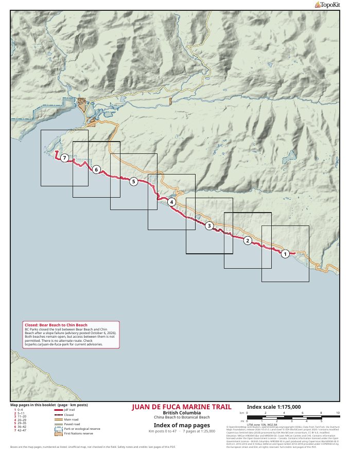
-
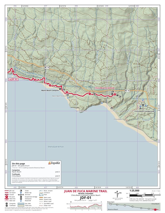 JDF-01
China Beach trailhead to Mystic Beach
km 0–4
-
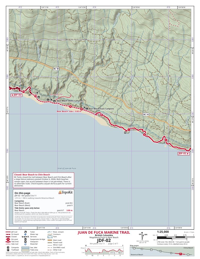 JDF-02
Magdalena Point to Bear Beach
km 5–11
-
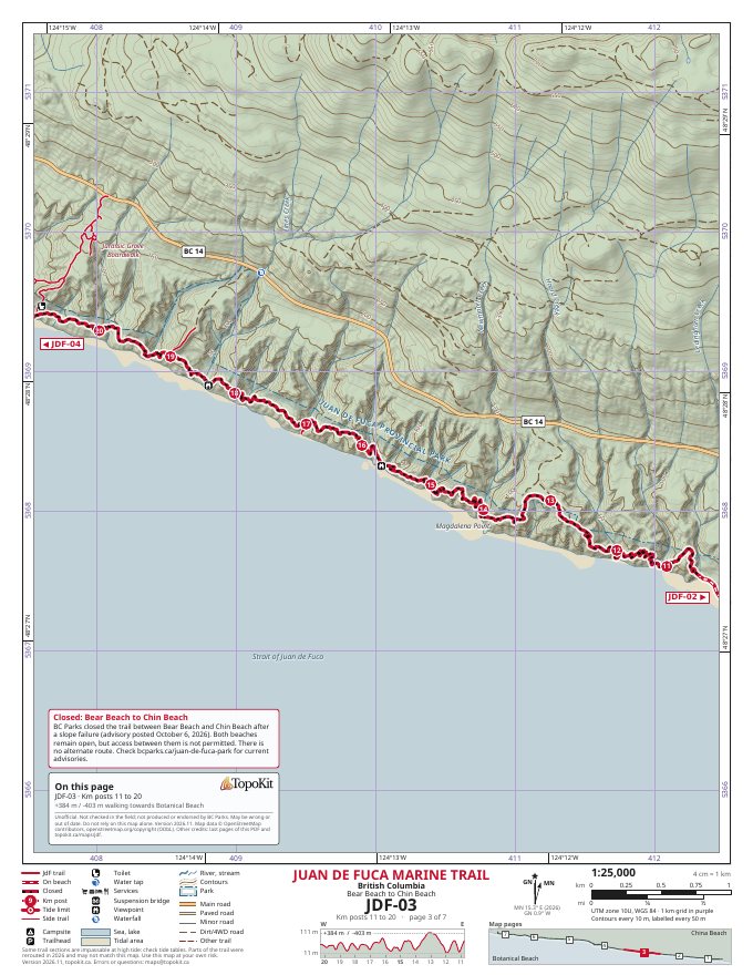 JDF-03
Bear Beach to Chin Beach Closed
km 11–20
BC Parks closed this section after a slope failure, as of October 6, 2026, and there's no alternate route. Current advisories
-
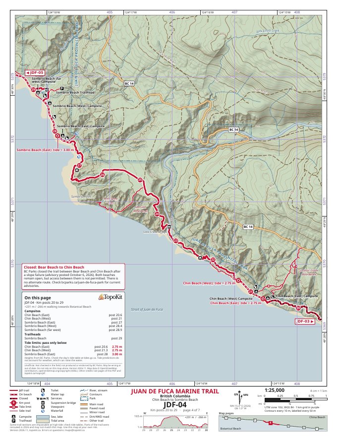 JDF-04
Chin Beach to Sombrio Beach
km 20–29
-
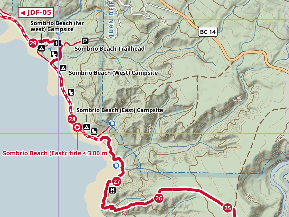
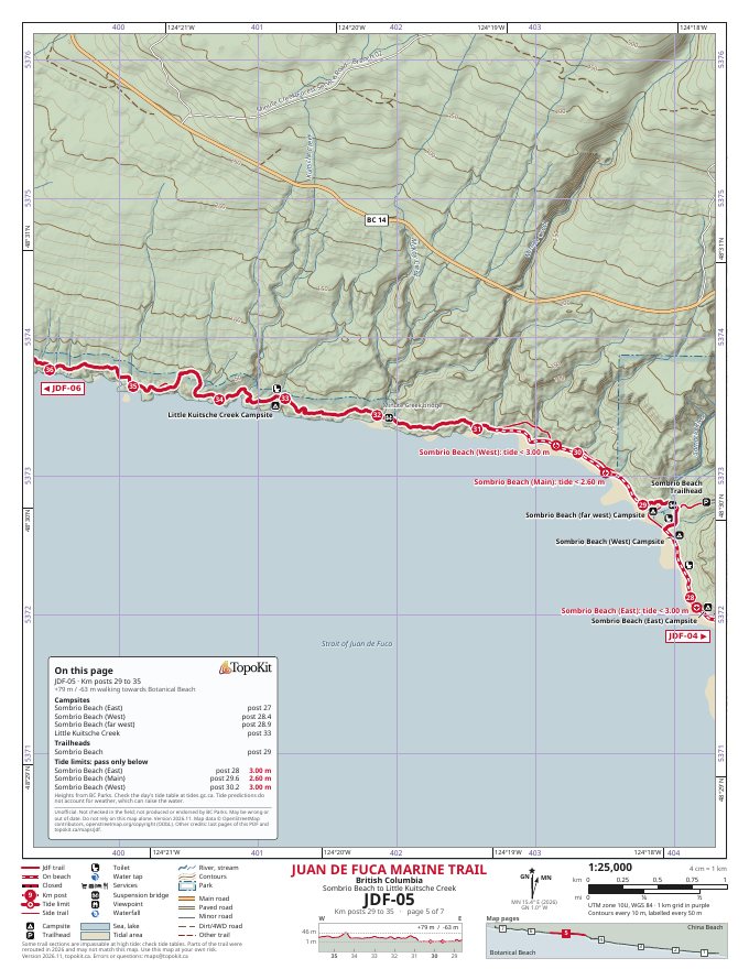 JDF-05
Sombrio Beach to Little Kuitsche Creek
km 29–35
-
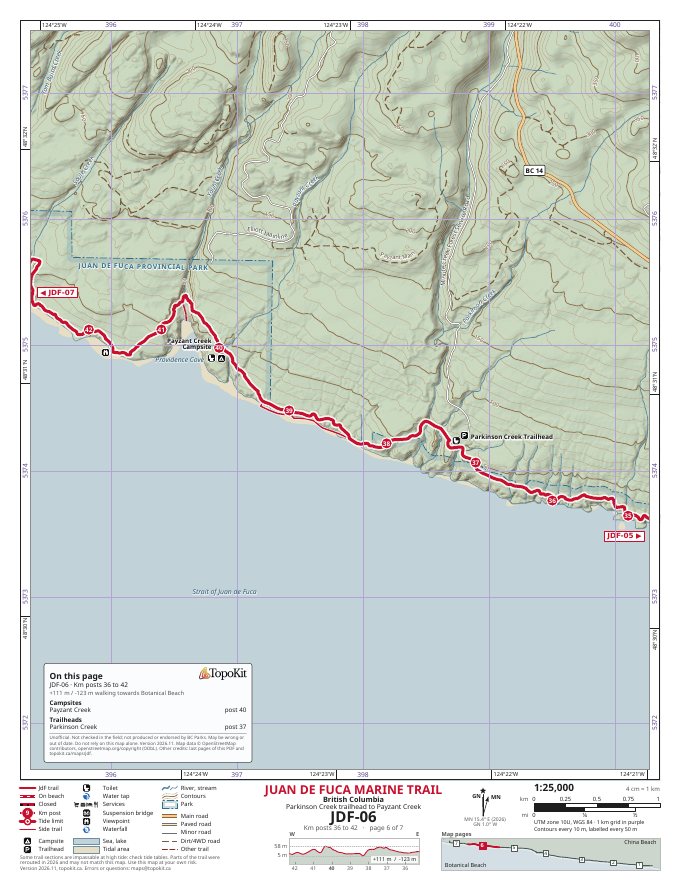 JDF-06
Parkinson Creek trailhead to Payzant Creek
km 36–42
-
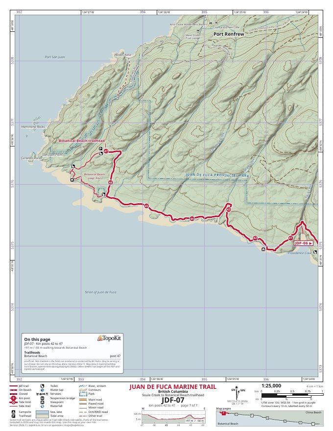 JDF-07
Soule Creek to Botanical Beach trailhead
km 42–47
What's on the maps
Each map is north-up at 1:25,000 when printed at actual size on US Letter paper, meaning 4 cm on the page represents 1 km on the ground. Along with the trail and its kilometre posts, the maps show campsites, trailheads, toilets, viewpoints, waterfalls, suspension bridges and the six tide limits identified by BC Parks. Each tide limit is labelled with the height the tide must be below for that section to be passed.
The maps use 10 m elevation contours over shaded relief, with elevation data from Natural Resources Canada's HRDEM lidar and MRDEM-30 models. They also include a 1 km UTM grid and an elevation profile showing the terrain along each section. The coastal shading extends to the mapped low-tide line and doesn't distinguish between sand and exposed rock, while white dashes along the red trail line indicate sections estimated to follow the beach.
BC Parks lists the trail as 47 km long, although the route shown on these maps measures 40.4 km, so the kilometre-post numbers are better used to identify locations than to calculate how far you've walked. The notes at the end of the PDF explain where the data came from and how I prepared the maps.
Before you go
These maps are unofficial and were made using publicly available geographic data. They haven't been checked in the field and aren't produced or endorsed by BC Parks or any other land manager. The Juan de Fuca Marine Trail is in the territory of the Pacheedaht First Nation.
Some sections of the trail are impassable at high tide, and the beach shading or white dashes on the maps shouldn't be used to decide whether a crossing is safe. Check the Port Renfrew tide predictions against the tide limits marked on the maps, keeping in mind that weather and waves can raise the water above predicted levels. From early November to mid-March, a phone connected to a US cell tower may also show a time one hour behind BC's local time.
Parts of the trail were rerouted in 2026 and may not match the mapped route, so follow the trail on the ground and check BC Parks for updated conditions. Camping requires a backcountry camping permit, and the BC Parks website has information about current regulations, fees and advisories. Always carry another reliable way to navigate rather than depending on these maps alone.
Change log
I'll post revised versions here when they're available, although I can't promise a regular update schedule.
- 2026.11 · November 11, 2026 · First version.
Sharing and terms
© 2026 Nikolay Senilov. You may share the booklet free of charge, whole and unchanged, but you may not sell it or change it. The map data belongs to its sources, under the licences listed below. If you share the maps, a link to this page helps people find the latest version.
The maps are provided as they are, with no promise that they're accurate, complete or current. To the extent the law allows, Nikolay Senilov and TopoKit aren't responsible for any loss or injury from using them.
Questions and errors
If you find something wrong with the maps, or have information that could help improve them, you can contact me at maps@topokit.ca. Including the map number and approximate kilometre post will help me find the location.
Credits
Map data © OpenStreetMap contributors, made available under the Open Database License (ODbL): openstreetmap.org/copyright. Data from TomTom. Via Overture Maps Foundation (overturemaps.org), release 2026-10-21.0.
Places, elevation, coast, land cover and the other sources
- Places include data from Meta and Microsoft (CDLA Permissive 2.0, cdla.dev/permissive-2-0), Foursquare (Copyright 2024 Foursquare Labs, Inc. All rights reserved. Apache 2.0, apache.org/licenses/LICENSE-2.0; notice: opensource.foursquare.com/places-notice-txt; transformed to the Overture schema) and AllThePlaces (CC0 1.0), via Overture Maps Foundation.
- Elevation: High Resolution Digital Elevation Model (HRDEM) lidar mosaic and Medium Resolution Digital Elevation Model (MRDEM-30), Natural Resources Canada. Coast and place names: CanVec, Natural Resources Canada. Low-tide line: Canadian Hydrographic Service, from BC's CHS Low Water Mark Lines. Contains information licensed under the Open Government Licence – Canada and the Open Government Licence – British Columbia.
- Kilometre values, tide limits and tide heights: BC Parks, Juan de Fuca Marine Trail map (November 2023). Closure: BC Parks advisory posted October 6, 2026. Reroutes and territory: BC Government news release 2026ENV0020-000464. Botanical Beach closure: BC Government information bulletin 2026ENV0028-000694. Drinking water and garbage: BC Parks, bcparks.ca/juan-de-fuca-park, read November 7, 2026.
- Land cover © ESA WorldCover project 2020 / Contains modified Copernicus Sentinel data (2020) processed by ESA WorldCover consortium. Licensed under CC BY 4.0 (creativecommons.org/licenses/by/4.0). Source: ESA WorldCover 10 m 2020 v100, doi.org/10.5281/zenodo.5571936, via Overture Maps Foundation. Reclassified and combined with shaded relief for these maps.
- MRDEM-30 was in part produced using Copernicus WorldDEM-30 © DLR e.V. 2010-2014 and © Airbus Defence and Space GmbH 2014-2018 provided under COPERNICUS by the European Union and ESA; all rights reserved. The organisations in charge of the Copernicus programme by law or by delegation do not incur any liability for any use of the Copernicus WorldDEM-30.
- Magnetic declination: NOAA NCEI and the British Geological Survey, World Magnetic Model 2025 (public domain).
- Map symbols: Pinhead icons by waysidemapping (github.com/waysidemapping/pinhead), public domain (CC0 1.0). The suspension bridge symbol was drawn for these maps.
- Fonts: Noto Sans, SIL Open Font License 1.1; DejaVu Sans, under its own free licence (dejavu-fonts.github.io).
- App Store is a service mark of Apple Inc., registered in the U.S. and other countries and regions.
- Cover image: Copernicus Sentinel-2, November 24, 2023, with shadows filled from September 15, 2023, and its colours adjusted for these maps. Contains modified Copernicus Sentinel data 2023.