

Vector Import & Export
TopoKit reads GPX, KML, KMZ, GeoJSON, and GeoPackage, and writes all of them except KMZ.
Everything in a TopoKit project is stored in WGS84 (EPSG:4326, decimal degrees). Imports are converted on the way in and every export is written back out in WGS84.
Importing
Section titled “Importing”On Mac, choose Add Vector from the plus menu in the Layers tab, click Import Vector in the tool sidebar, or drag files from Finder onto the window. Double-clicking a supported file in Finder also opens it.
On iPhone, tap plus in the Layers tab and choose Add Vector, then pick a file from the Files picker (iCloud Drive, On My iPhone, or any file provider). A supported attachment also opens from Mail, Messages, or Safari with Open With → TopoKit.
Parsing runs in the background, so you can pan the map and work with other layers while a large file loads. Imported features are added to the layer tree as one folder named after the file, with every imported feature as a direct child row of that folder.
If a file cannot be parsed at all, an alert explains why. Anything short of that is silent — skipped features and empty files are only logged — so check the imported feature count against what you expected.
GPX, KML, and GeoJSON imports are capped at 100 MB; GeoPackage has no size cap. Every imported feature stays in memory either way, so clip a large file to your area of interest in a desktop GIS before importing.
Supported import formats
Section titled “Supported import formats”Everything TopoKit reads, and what arrives from each format:
| Format | Extensions | Geometry types | Attributes |
|---|---|---|---|
| GPX | .gpx | Waypoints (Point), Routes (LineString), Tracks (LineString / MultiLineString) | Partial (name, description, track_* stats) |
| KML | .kml | Point, LineString, Polygon | Name, description, <ExtendedData> attributes |
| KMZ | .kmz | Same as KML | Same as KML |
| GeoJSON | .geojson, .json | Point, MultiPoint, LineString, MultiLineString, Polygon, MultiPolygon, GeometryCollection, bare geometries | Full (all properties preserved as strings) |
| GeoPackage | .gpkg, .geopackage | All of the above, plus Z and M — see GeoPackage | Full (all feature-table columns preserved as strings) |
Styling is never read from any format: imported lines and polygons take the Imported Line Style and Imported Polygon Style defaults (Settings → Data Defaults), which are kept separate from your drawing defaults so imported features do not pick up your drawing style. Imported points take the app-wide Default Point Style, the same one your own dropped pins use. Restyle them afterward.
GPX files are parsed per GPX 1.1. Waypoints, routes, and tracks are all added as sibling rows inside a single folder named after the file; a multi-segment track arrives as one MultiLineString feature. Segments with fewer than two points or under 5 m of total length are dropped first; the survivors are chained end-to-end by proximity, which can reverse a segment. The same cleanup runs on every imported MultiLineString, whatever the format it arrived in. Per-vertex elevation and time are captured from any GPX; horizontal accuracy is read only from TopoKit’s own <topokit:hAccuracy> extension. The importer reads only <ele>, <time>, <name>, <desc>/<cmt> and TopoKit’s own extensions. Vertical accuracy is not carried in GPX in either direction. TopoKit’s recorded-track stats round-trip through <extensions>.
Extensions written by other apps, and any track colours or icons, are dropped. A <wpt> with missing or out-of-range coordinates is skipped.
KML is read from <Placemark>: points, lines, and polygons with holes, plus <description> and <ExtendedData> attributes. Altitude is kept as each vertex’s elevation. <gx:Track> and <gx:MultiTrack> come in with their per-point timestamps and accuracy; a <gx:MultiTrack> is split like <MultiGeometry>, each track arriving as its own line feature sharing the placemark’s name and attributes.
Three kinds of KML content are not imported:
<MultiGeometry>. The parts are not rebuilt into one multi-part feature. Each part arrives as its own separate feature instead, sharing the placemark’s name and attributes, so a placemark holding three polygons becomes three polygons. Use GeoJSON or GeoPackage if you need the parts kept together.<Folder>nesting. Flattened: everything lands under one folder named after the file.<SchemaData>/<SimpleData>. Only the<Data name="…"><value>form of<ExtendedData>is read, so typed schema attributes do not arrive at all.
TopoKit opens a .kmz archive and parses the first .kml inside it as described for KML; any other KML documents, embedded icons, and overlays are ignored, and encrypted archives will not open.
GeoJSON
Section titled “GeoJSON”GeoJSON is parsed per RFC 7946. A FeatureCollection, a lone Feature, or a bare geometry all work, and a GeometryCollection is expanded into separate features sharing one properties block.
GeoJSON and GeoPackage are the two formats where attributes survive import in full. Every properties key is kept as a string (numbers and booleans stringified, null dropped). The importer picks a display name from the first non-empty match among name, Name, NAME, title, Title, TITLE, label, Label, LABEL. Two keys are reserved: coordTimes and coordHorizontalAccuracy are read as per-vertex time and accuracy arrays, not as text.
Nested objects and arrays arrive as opaque text rather than being decomposed — flatten them in your desktop GIS first if you need the values as separate properties. A non-WGS84 "crs" member is ignored: coordinates are always read as [lon, lat], so reproject old GeoJSON before importing.
GeoPackage
Section titled “GeoPackage”Every feature table’s rows are added as sibling feature rows in the one folder named after the file; every non-geometry column becomes a string property, and a name or title column, in any capitalization, sets the feature name. Z is kept as per-vertex elevation. M is read as a per-vertex timestamp when the values look like unix time, and dropped otherwise.
GeoPackage is the only import format whose CRS TopoKit acts on: anything that is not WGS84 is reprojected on the way in. If a transform fails, the raw coordinates are kept.
Raster tile tables, geometry-less attribute tables, and GeoPackage styling extensions are not read.
Shapefile
Section titled “Shapefile”Not implemented, in either direction. Convert to GeoPackage (recommended) or GeoJSON first.
Coordinate validation
Section titled “Coordinate validation”Coordinates must fall inside the WGS84 bounds — latitude in [-90, 90], longitude in [-180, 180]. Out-of-range coordinates are handled differently per format, which changes what a partly-bad file looks like on the map:
- GPX and KML discard the offending vertex and keep the rest of the feature — the line draws with a notch in it. KML longitude is normalized into range before this check, so a KML vertex is only ever discarded for its latitude. A point has only one vertex, so an out-of-range point is dropped outright in both formats.
- GeoJSON skips the entire feature in a
FeatureCollectionif any single coordinate is out of range. A file that is a loneFeatureor a bare geometry fails the whole import with an error alert instead, and inside aGeometryCollectiononly the offending sub-geometry is dropped. - GeoPackage keeps out-of-range but finite coordinates, so they render somewhere wrong rather than disappearing.
Exporting
Section titled “Exporting”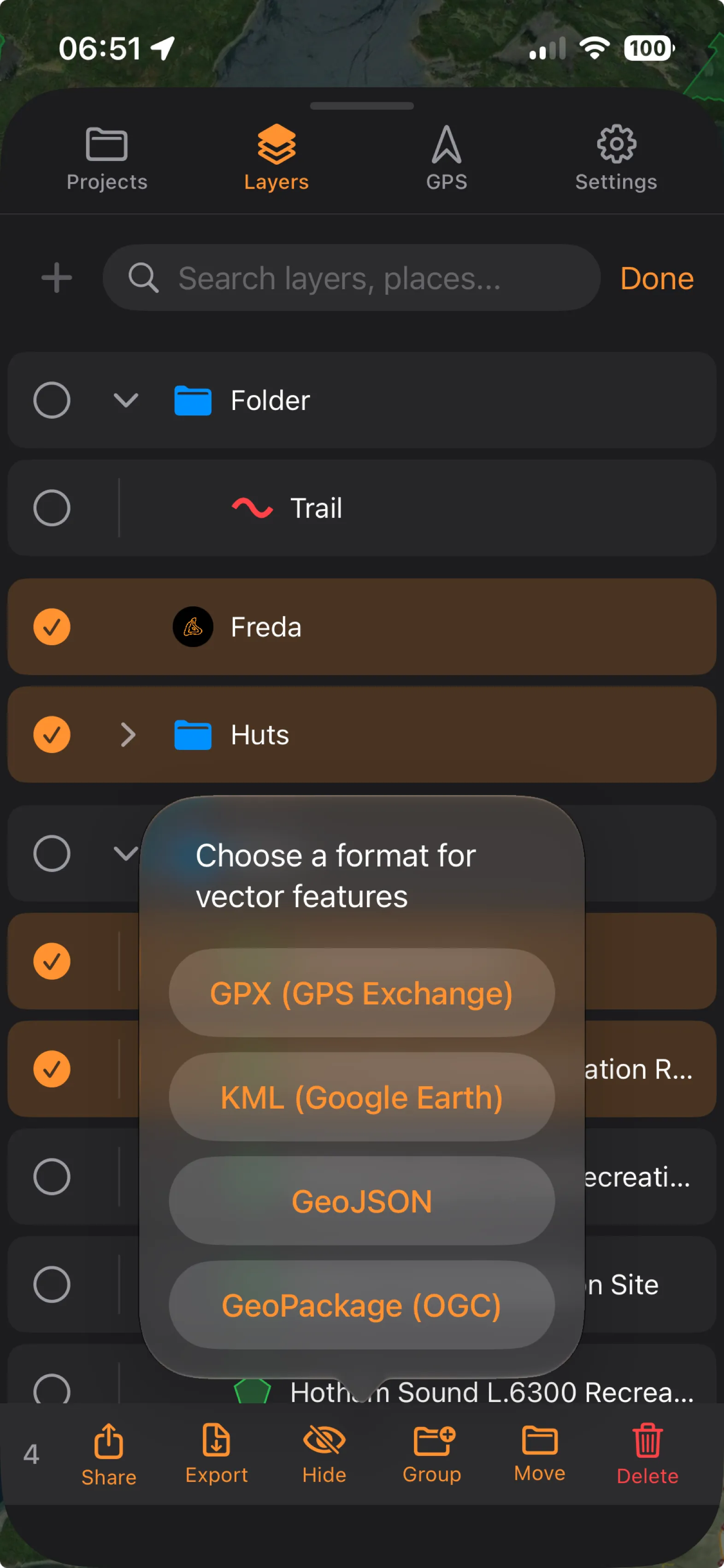
Select what to export: a single feature, a folder and everything in it, or a multi-item selection. There is no whole-project export to any of these formats: to take everything, select your top-level items in Select mode and export them together.
On Mac, right-click the item, choose Export to File, and pick a format; a standard Save panel then asks where to write the file.
On iPhone, tap the row’s More button and choose Export to File, or select multiple items in Select mode and tap Export in the action bar. Either route asks for a format, then opens a Files save-location picker: choose a folder in iCloud Drive, On My iPhone, or another file provider. The separate Share action in the same menu opens the share sheet instead.
Supported export formats
Section titled “Supported export formats”Everything TopoKit writes, and what each format can carry:
| Format | Extensions | Geometry types | Attributes | Styling | Notes |
|---|---|---|---|---|---|
| GPX | .gpx | Point → <wpt>, lines → <trk> | Name + description (track stats appended)Full | None | Polygons are silently dropped. |
| KML | .kml | All six geometry types (Point, MultiPoint, LineString, MultiLineString, Polygon, MultiPolygon) | Name + description (track stats appended)Full | Fixed defaults only | Multi-part geometry and polygon holes survive. |
| GeoJSON | .geojson | All six geometry types | Full | None | A key-sorted FeatureCollection. |
| GeoPackage | .gpkg | All six geometry types, with polygon holes and multi-part geometry preserved | Full (a column per property, all TEXT) | None | Split into up to three tables by geometry type — see the round-trip FAQ. |
GPX export
Section titled “GPX export”The export is GPX 1.1: points become <wpt>, all lines become <trk> (never <rte>). A MultiPoint is flattened to one <wpt> per vertex, every one of them carrying the parent feature’s name and description, so it cannot be reassembled into a single feature on re-import. Recorded-track stats are appended to <desc> as readable text, with the machine-readable track_* values in <extensions>. A waypoint’s own properties are written to its <extensions> the same way, so the accuracy, altitude, speed, heading and time recorded with a GPS-captured point leave with it. TopoKit does not read those waypoint properties back on import, so a GPX exported and re-imported keeps the points and loses their recorded GPS detail. Use GeoPackage or GeoJSON for a round-trip. The readable text is always metric and always English, whatever your unit and language settings. Polygons cannot be expressed in GPX and are silently dropped.
KML export
Section titled “KML export”The export is OGC KML 2.2: one <Document>, one <Placemark> per feature; multi-part features use <MultiGeometry> and polygon holes survive. Recorded tracks are written as <gx:Track> / <gx:MultiTrack> with per-point time, altitude, and accuracy intact. Only lines carrying TopoKit’s track_* stats count as recorded tracks here: a line with per-vertex timestamps but no track stats — a <gx:Track> imported from another app, say — exports as a plain <LineString>, and its per-vertex times and accuracies are dropped.
Feature properties are not written: a placemark carries only its name and description, so attributes that arrived through <ExtendedData> on import do not leave on export. The one exception is a recorded track, whose track_* stats are written back as <ExtendedData>.Feature properties are written as <Data> entries in <ExtendedData> on the placemark, so attributes that arrived on import leave again on export. Name and description are not repeated there, because both already have their own elements.
Your styling is not exported. Every placemark gets one of three fixed defaults — yellow pushpin, red line, red translucent polygon — so your custom pin colours, widths, and fills will not appear.
GeoJSON export
Section titled “GeoJSON export”The export is an RFC 7946 FeatureCollection, pretty-printed with sorted keys so diffs stay stable. Coordinates are [lon, lat], or [lon, lat, elevation] if any vertex in the feature has elevation — vertices lacking it get a literal 0, not null. Properties are typed on the way out: numeric strings become numbers, "true"/"false" become booleans, everything else stays a string. That retyping is lossy for identifiers with leading zeros — a site_id of "007" exports as 7. Export to GeoPackage instead if those matter: every property column there is TEXT.
coordTimes and coordHorizontalAccuracy are reserved on the way out as well as on the way in — if a feature carries per-vertex times or accuracies, the generated arrays overwrite any properties of yours with those names. A name property likewise takes precedence over the feature’s own name, so a feature you renamed in TopoKit exports under the name attribute it was imported with.
GeoPackage export
Section titled “GeoPackage export”The export is a .gpkg per the OGC GeoPackage specification, with features split into points, lines, and polygons tables, skipping any that would be empty. Each property key becomes a TEXT column with its name sanitized to letters, digits, and underscores — so site id arrives as site_id. Where two keys sanitize to the same column, only one survives, and a property named name, fid, or geom (in any capitalization) is dropped — those column names are reserved. Recorded tracks export with full XYZM: elevation as Z, per-vertex timestamps as M, and horizontal accuracy in a sidecar table written via the OGC Related Tables Extension. The M column is all-or-nothing per table — if the same export also contains a line without a timestamp on every vertex, no timestamps are written for any line in the table. Everything is tagged SRS 4326 (WGS84).
Why did my styling disappear?
Styling is neither imported nor exported. Nothing is read from an imported KML, and nothing of yours is written to an exported one — KML export uses three fixed defaults. Restyle after importing. If it is the attributes you need to preserve rather than the look, use GeoPackage or GeoJSON.
Why are my features in the wrong place?
Every vector format TopoKit reads fixes its own axis order in the spec — GPX names lat and lon outright, KML is lon,lat, GeoJSON is [lon, lat], GeoPackage stores (x, y). TopoKit never has to guess. If imported vectors land in the wrong hemisphere or mirrored across the map, the file was written with its coordinates swapped by the exporting tool; fix it in your desktop GIS and re-import. The other possibility is a non-WGS84 CRS TopoKit cannot act on — GeoPackage is the only format whose CRS it reads. Georeferenced rasters are the one place a CRS is genuinely ambiguous. See Raster overlays.
How do I round-trip a project through GeoPackage?
GeoPackage is the best round-trip format: attributes survive in full and are never re-typed.
- Export your folder — or a Select-mode selection of your top-level items — to
.gpkg. - Open it in your desktop GIS, edit it, and save.
- Re-import the file into TopoKit.
Features land in a new folder, attributes come back as string properties, and any reprojected coordinates convert back to WGS84. Styling added externally is not read.
What survives intact: geometry to full coordinate precision, polygon holes and multi-part polygon geometries, per-vertex Z as elevation and M as timestamp, and every attribute value.
What does not:
- Layer structure. Export writes up to three tables —
points,lines,polygons— split by geometry type, and nothing records which layer a feature came from, so a five-layer GeoPackage comes back with its source layers merged. Add your own layer-name column before exporting if you need to rebuild the split. - Multi-part line segments. Re-import drops segments under 5 m and re-chains the rest by proximity, possibly reversing them — the same cleanup described under GPX.
- Column types. Every column is written as
TEXTand read back as a string. An INTEGER, REAL, DATE, or BOOLEAN column returns as text, so expressions and joins against it will need re-casting. - Identity. Each import assigns new identifiers, so carry a stable attribute of your own (a
site_idorsurvey_code) if you need persistent identity across the trip. Keep it out of the reserved names (name,fid,geom); a zero-padded identifier survives a GeoPackage round trip but not a GeoJSON one. - Anything you needed to edit. Attributes are read-only in TopoKit, so a round trip can move values but never correct them. See Points, Lines, Polygons & Circles.