

Elevation & DEMs
TopoKit reads point elevations and route climb from a global digital elevation model, and works offline once its tiles are downloaded.
Elevation data source
Section titled “Elevation data source”Elevation comes from the Copernicus GLO-30 Digital Elevation Model, distributed as 1°×1° tiles. Each value covers about 30 metres of ground, measured from sea level rather than from the ellipsoid. That has three consequences:
- Terrain narrower than about 30 metres — a gully, a levee bank — is not in the model at all.
- Values are orthometric: comparable to what a topographic map calls elevation above sea level, not to the ellipsoidal height a GNSS receiver reports. The two differ by roughly −100 m to +85 m depending on where you are.
- The model is a surface: in forested or built-up areas the value can be canopy or roof rather than bare earth.
No other elevation source is supported. A GeoTIFF you load as a raster is drawn as imagery, not read as elevation.
Downloading tiles
Section titled “Downloading tiles”A tile reaches your device one of two ways: a query fetches it, or you select it in the DEM Tile Manager. Both store tiles in the app’s own data area rather than a temporary cache, so they survive reboots until you remove them. A tile runs 25–40 MB, depending on latitude and terrain.
On demand
Section titled “On demand”A query whose tile is already on the device reads it from storage and makes no network request. What happens when the tile is missing depends on where you asked from:
- The elevation measurement tool shows Download N elevation tiles (X MB) on the tool card, and downloads nothing until you tap it.
- The point editor shows Get Elevation with the download size beside it.
- The elevation profile on a saved line downloads without asking, and what you are told beforehand depends on where you open it. In quick edit the Elevation Profile button carries a subtitle naming the tile count and estimated size, but tapping it starts the download rather than opening a confirmation. From the layer tree’s context menu there is no subtitle and no estimate: the download starts the moment you choose Elevation Profile.
The DEM Tile Manager
Section titled “The DEM Tile Manager”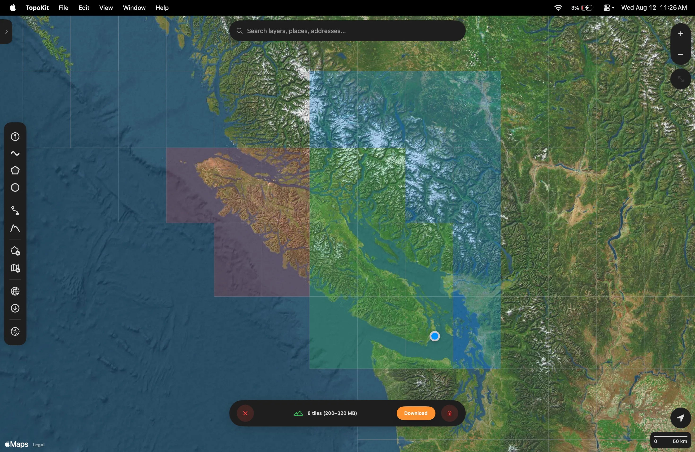
Open the Tile Manager from Download Data, then the Elevation Data card. On Mac, Download Data is in the tool sidebar. On iPhone, Download Data is in the Layers tab’s plus menu. A grid appears over the map, and each cell shows its state:
- Green: already on disk.
- Blue: selected for download.
- Red: selected and already on disk, so it is flagged for deletion instead.
- Grey: a cell whose download previously failed.
- No cell at all: the dataset does not publish that area, so there is nothing to select.
Select the cells you want and choose Download. The bar counts the new tiles and estimates their size, and a tile the network drops is retried on its own.
Selecting a cell that is already on disk flags it for deletion rather than download, and a red trash button appears in the bar to remove exactly those tiles.
Reviewing and deleting tiles
Section titled “Reviewing and deleting tiles”Open Settings → Storage & Cache and find the Elevation Data section:
- Manage Tiles opens Downloaded Elevation Tiles, one row per tile with its size and a delete button. It stays unavailable until you have downloaded at least one tile.
- Clear All deletes every downloaded tile, asking first and naming the count and total size.
To clear a whole corner of the map instead of picking tiles off a list, select those cells in the Tile Manager.
Coverage gaps
Section titled “Coverage gaps”The dataset does not cover every cell: open ocean, most of Antarctica, and cells above 83°N are not published. In the Tile Manager those cells carry no grid overlay, so you cannot select them, and a point elevation query there returns no value.
Armenia and Azerbaijan are absent from the release TopoKit reads, so they behave the same way: no cell to select, and no elevation to return.
A profile that crosses water draws straight through the gap. The chart connects the shore points on either side, so a flat span over water is interpolation rather than data. A note below the chart reads “Some elevation data unavailable (N tiles missing)”.
That note counts whole tiles that are not on disk. Where a downloaded tile simply holds no value under your line — a NoData pixel at a coastline or an ice sheet — those samples are dropped with no note at all.
Disk-space planning
Section titled “Disk-space planning”For rough planning, assume 30 MB per tile and work out how many 1°×1° cells your area covers:
- A single county or watershed: 1–4 tiles, roughly 30–120 MB.
- A moderate-sized US state or small European country: 20–40 tiles, 600 MB to 1.2 GB.
- A whole continent: thousands of tiles, hundreds of GB.
Elevation queries: point and profile
Section titled “Elevation queries: point and profile”TopoKit answers two kinds of elevation question.
Point elevation. TopoKit finds the covering tile and interpolates between the four surrounding DEM values. If any of the four is NoData, the result is empty rather than zero.
Profile along a line. TopoKit samples the line about every 30 metres, matching the DEM’s own resolution, and builds a series of distance and elevation pairs. A segment shorter than 30 metres still contributes a sample at its far vertex, so a saved GPS track with fixes a few metres apart is sampled at every fix.
Moving along the chart marks the matching spot on the map, so you can see where a climb or a drop actually is. On Mac, the marker follows the cursor. On iPhone, drag along the chart.
The stats below the chart:
- Min, Max and Avg: taken from the samples, so a summit falling between two samples is not in the maximum.
- Gain and Loss: the sums of the positive and negative steps between samples.
- Distance: the real length of the line, summed segment by segment, not the sample count multiplied by 30 metres.
The Elevation Profile tool
Section titled “The Elevation Profile tool”The tool sidebar’s Elevation Profile button is separate from the profile you open on a saved line: it builds a temporary path and charts it without saving a layer. It offers two modes:
- Points mode: tap the map to drop waypoints, and TopoKit connects them with straight segments.
- Route mode: tap a start and an end, and TopoKit follows a road route from Apple Maps directions — walking by default, switchable to driving — sampling elevation along the real road geometry.
Both modes share the same chart and stats. You can switch modes mid-measurement; the placed points and the panel reset.
The Save button on the tool card opens the same line editor a drawn line opens, so you can name the feature before it is saved.
Why is elevation missing in some areas?
Either the cell is not published at all, or the tile is downloaded and the pixels under your query hold no value — most often near coastlines and ice sheets. See Coverage gaps.
Why is the elevation different from my handheld GPS reading?
Your receiver reports height above the ellipsoid while the DEM stores height above sea level, and the two differ by tens of metres almost everywhere. GLO-30 is also a surface model at 30-metre resolution, so it does not resolve the exact spot you are standing on. See Elevation data source.
Can the app work with elevation when offline?
Yes, as long as the tiles are already on disk: lookups read them straight from storage, so they behave the same with or without a connection. If a tile is missing and you have no connection, the download waits for the network rather than failing — close the panel and fetch the tiles when you are back online.